Blog Image

OF SPACES IN-BETWEEN

CULTURE | SPACE | TRAVEL | MEMORY

LIMINOIDS.COM

Triangulation exhibition: VG&M

Maps & Mapping Posted on 17 Jul, 2019 11:22:45

TRIANGULATION

An exhibition at the Victoria Gallery and Museum Liverpool by the photographers Stephanie Wynne and Stephen McCoy as part of LOOK Liverpool Photographic Festival.

18 July – 24 August 2019

Location: Gallery 7, first floor, VG&M

http://vgm.liverpool.ac.uk/exhibitions-and-events/special/triangulation/

http://mccoywynne.co.uk/projects/triangulation.aspx


Below is a short written piece I produced to accompany the exhibition:

TRIANGULATION: A SPATIAL STORY IN THREE PARTS

Triangulation. The word has an air of precision about it. From the careful placing of the theodolite on the trig pillar, to the no less careful eye of the surveyor scanning a point in the distance, through to the geometric delineation of a landscape rendered in two dimensions, it is important to be precise. The rationalising and abstraction of space that defines the process of map-making – a mediation of the world that we are at once immersed within and standing back from – is analogous to that routinely invested in the work of the landscape photographer. Does a photograph map the topographic features being gazed upon by the photographer? Perhaps, perhaps not. It depends on how you are defining ‘map’. But what both forms of media do nevertheless impart is their ‘propositional character’, as Denis Wood suggests in his book Rethinking the Power of Maps. Both map and photographic image throw us something we then take it upon ourselves to do something with by way of response.

In the hands of photographers Stephanie Wynne and Stephen McCoy, Triangulation (the project) invites us to rethink the practice of triangulation and to enter into – or at least be more attentive to – a compelling dialogue unfolding between cartography and photography; between map-making and image-making. The way it does this is by offering us another form of triangulation, one that draws a tentative but discernible line between three discreet fields of knowledge; or, to borrow from cultural theorist Michel De Certeau, between three spatial stories.

The first of these is the story of how the British Ordnance Survey map came into being. Triangulation conjures a history of triangulation that speaks as much to the technological leaps and bounds that helped shaped innovations in cartography since the founding of the Ordnance Survey in 1791, as it does the geographical particularities of Great Britain as an island-nation and as a landmass set apart from continental Europe. Set against the backdrop of a nation grappling with the uncertainties of Brexit, Triangulation helps incite reflection on the extent to which the points we choose to triangulate necessarily need to fall within the political boundaries of the nation-state.

The second spatial story has a much deeper provenance, one that trails its way through cultural histories of landscape, where the process of ‘putting a frame’ (literally and metaphorically) around a part of the world – a cityscape here, an affecting rural prospect there, a Shangri-La beyond the horizon (somewhere over the rainbow) – is a part of how people down the ages have gone about the task of making that world. The aesthetics of landscape can be as rigorously disciplined or as messily chaotic as circumstances and artistic dispositions demand. In Triangulation we are privy to both the exactingly precise and the serendipitous workings of chance. As with the surveyor who has hauled his or her theodolite across a field or up a rocky incline, McCoy and Wynne, having found where X marks the spot, carefully erect their camera and tripod atop the triangulation pillars. What follows is a 360° panoramic scan that is enacted with the same degree of care as that expected of the Ordnance Survey cartographer. But in other respects, aesthetic considerations are obviated by the necessity to frame the view as they find it, whatever the weather and the challenges posed by the relentless buffeting of wind. Happenstance, and the simple need to get the job done, removes much of the burden of agency.

The third spatial story provides a tantalising glimpse into the trials and travails of the getting there. This is a story whose telling takes place outside the frame. It describes the coalescence of ideas and inspiration, of entwined creative ambitions, the gradual emergence of a realisable project, the aesthetic conviction and ‘mapping impulse’ that drives the process through to fruition. It describes a quest or an odyssey of sorts, a tale that is only fleshed out in its telling. It may even be suggested that Triangulation is the enactment of a form of pilgrimage inasmuch as any sacred journey is destined to reap a reward, something that is brought back to the mundane world. If we accept such a conceit, then each of these images may be looked upon as talisman or souvenir whose function is to prompt enunciation, whether this be the telling of the spatial story inscribed in the making of the image, or the calling out of what are otherwise neglected markers of cultural and industrial heritage. We might also consider whether each of these images is perhaps a stepping stone in a pilgrimage that can only be fully realised when all of the primary trig pillars still standing (310 at the last count) have been photographically mapped. But that would be to sketch the contours of a spatial story as yet untold.

Les Roberts, July 2019.


Cities and Memory – sound mapping

Maps & Mapping Posted on 13 Feb, 2017 10:59:02

Details about the Cities and Memory project(s), from http://citiesandmemory.com/


What is Cities & Memory?

Cities and Memory is a global field recording & sound art work that presents both the present reality of a place, but also its imagined, alternative counterpart – remixing the world, one sound at at time.

Every faithful field recording document on the sound map is accompanied by a reimagination or an interpretation that imagines that place and time as somewhere else, somewhere new.

The listener can choose to explore locations through their actual sounds, to explore reimagined interpretations of what those places could be – or to flip between the two different sound worlds at leisure.

There are currently over 1,400 sounds featured on the sound map, spread over more than 55 countries.

The sounds cover parts of the world as diverse as the hubbub of San Francisco’s main station, traditional fishing songs on Lake Turkana, the sound of computer data centres in Birmingham, spiritual temple chanting in New Taipei City or the hum of the vaporetto engines in Venice.

The sonic reimaginings or reinterpretations can take any form, and include musical versions, slabs of ambient music, rhythm-driven electronica tracks, vocal cut-ups, abstract noise pieces, subtle EQing and effects, layering of different location sounds and much more.

The project is completely open to submissions from field recordists, sound artists, musicians or anyone with an interest in exploring sound worldwide – more than 350 contributors have got involved so far.

http://citiesandmemory.com/sacredspaces/


The lie of the land: when map makers get it wrong

Maps & Mapping Posted on 13 Feb, 2017 10:37:19

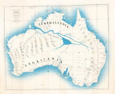
Australia’s inland sea: Some maps are purely speculative, but the cartography can be striking nonetheless. This map accompanies Thomas J Maslen’s The Friend of Australia (1830), a work of pure theory in which the English writer suggests that there could be a wealth of river and fertile paradise lying hidden in the heart of Australia. The centrepiece of this colonial fantasy is a great lake the size of a small sea, placed plum in the desolate centre of what is now known as the Simpson Desert.

The history of cartography is littered with mistakes, myths and mendacity. From the magnetic mountain at the north pole to Australia’s inland sea, Edward Brooke-Hitching charts five centuries of misrepresentative maps…

https://www.theguardian.com/books/gallery/2016/nov/16/the-lie-of-the-land-when-map-makers-get-it-wrong-edward-brooke-hitching-in-pictures?


Alternative maps of NYC

Maps & Mapping Posted on 25 Jan, 2017 10:38:16

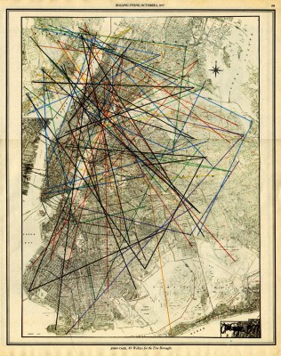
John Cage: 49 Waltzes for the Five Boroughs, 1977

Take a left at Drool Avenue: alternative NYC maps

A new book brings together odd maps of New York City, from cityscapes made of jelly to avant-garde musical compositions by John Cage…

www.theguardian.com/artanddesign/gallery/2017/jan/25/take-a-left-at-drool-avenue-alternative-nyc-maps-in-pictures?


Unmappable

Maps & Mapping Posted on 18 Jan, 2017 13:37:56

Unmappable
Diane Hodson and Jasmine Luoma (2014)

unmappable is a documentary short that weaves together the life and work of iconoclastic psychogeographer and convicted sex offender, Denis Wood. This meditative portrait will unveil the inner workings of a man whose work is lauded as poetic, artful and innovative – a man who unapologetically pushes boundaries both personally and professionally. The film explores the events that have defined his life by pointing at ideas, thoughts and beliefs that we usually do not think of as being mappable or explainable.

https://unmappablefilm.com/

Iconoclastic Mapmaker With a Sordid Past Is the Subject of a
New Documentary
Wired feature, 17 October 2014.


Sentimental Cartography

Maps & Mapping Posted on 18 Jan, 2017 13:20:31

Reblogged from SubmaP: Mapping Sao Paulo Development Blog
http://distributedcreativity.typepad.com/submap/2005/03/sentimental_car.html


Sentimental Cartography

Suely Rolnik

“To encounter is to find, to capture, to steal, but there is no method for finding, only a long preparation. Stealing is the contrary to plagiarizing, copying, imitating or doing as. The capture is always a double-capture, the stealing, a double-stealing, and this is what makes not something mutual, but an asymmetrical block, an a-parallel evolution, marriages, always ‘outside’ or ‘in-between’.”

-Gilles Deleuze and Claire Parnet, Dialogues Cartography: a provisional definition
To geographers, cartography-distinct from maps which are representations of a static whole -is a drawing that accompanies and creates itself at the same time as the transformation movements of the landscape.

Psychosocial landscapes can also have cartography. Cartography, in this case, accompanies and creates itself at the same time as the dismantlement of certain worlds-its loss of sense-and the formation of other worlds. Worlds that create themselves to express contemporary affects, in relation to which the cogent universes became obsolete.

If the task of a cartographer is to provide a language to demanding affects, it is basically expected of him that he would be immersed in the intensities of his time, and aware of the languages he encounters, he devour those which seem to him possible elements for the composition of those cartographies that deem themselves necessary.

The cartographer is first and foremost an anthropophagite.

The cartographer

The practice of a cartographer refers to, fundamentally, the strategies of the formations of desire in the social field. And little does it matter which sectors of the social life he chooses as an object. What matters is that he remains alert to the strategies of desire in any phenomenon of the human existence that he sets out to explore: from social movements, formalized or not, the mutations of collective sensitivity, violence, delinquency. . . up to unconscious ghosts and the clinical profiles of individuals, groups and masses, whether institutionalized or not.

Similarly, little matters the theoretical references of the cartographer. What matters is that, for him, theory is always cartography-and, thus being, it creates itself jointly with the landscapes whose formation he accompanies (including, naturally, the theory introduced here). For that, the cartographer absorbs matters from any source. He has no racism whatsoever regarding frequency, language or style. All that may provide a language to the movements of desire, all that may serve to coin matter of expression and create sense, is welcomed by him. All entries are good, as long as the exits are multiple. For this reason the cartographer makes use of the most varied sources, including sources not solely written nor solely theoretical. Their conceptual operators may equally arise from a film as from a conversation or a philosophy treatise. The cartographer is a true anthropophagite: he lives of expropriation, appropriation, devourment and delivery, transvalorized. He is always searching for nourishment to compose his cartographies. This is the criterion for his choices: to discover which matters of expression, mixed to which others, which language compositions favor the passage of intensities that traverse his body in the encounter with the bodies he intends to understand. In fact, “to understand”, for the cartographer, has no relation whatsoever with explaining and least of all with revealing. For him there is nothing high up there-skies of transcendence-, nor down under-the mists of essence. What there is high up there, underneath and everywhere are intensities looking for expression. And what he wants is to dive into the geography of affects and, at the same time, invent bridges to undertake his crossing: bridges of language.

We see that language, for the cartographer, is not a vehicle of messages-and-salvation. It is, in itself, creation of worlds. Flying carpet. . . Vehicle that promotes the transition to new worlds; new forms of history. We may even say that in the cartographer’s practice history and geography integrate themselves.

This allows us to make two further observations: the problem, for the cartographer, is not that of the false-or-true, nor of the theoretical-or-empirical, rather it is that of the vitalizing-or-destructive, active-or-reactive. What he wants is to participate, embark in the constitution of existential territories, constitution of reality. Implicitly, it is obvious that, at least in his happiest moments, he does not fear the movement. He allows his body to vibrate in all possible frequencies and keeps inventing positions from which these vibrations may find sounds, passage channels, a lift towards existentialization. He accepts life and surrenders. With body-and-language.

It would remain to know which are the cartographer’s procedures. Well, these do not matter either, for he knows that he must “invent them” based on what the context in which he finds himself demands. For this reason he does not follow any type of normalized protocol.

What defines, therefore, the profile of the cartographer is exclusively a type of sensitivity, which he sets himself to make prevalent, wherever possible, in his work. What he wants is to place himself, whenever possible, in the surroundings of the cartographies’ mutations, a position which allows him to welcome the finite unlimited character of the process of production of reality that is the desire. For this to be possible, he makes use of a “hybrid compound,” made out of his eye, of course, but also, and simultaneously, of his vibrating body, for what he looks for is to apprehend the movement that arises from the fecund tension between flux and representation: flux of intensities escaping from the plan of organization of territories, disorienting its cartographies, disrupting its representations and, in this way, representations stagnating the flux, channeling the intensities, giving them sense. It’s because the cartographer knows there is no other way: this permanent challenge is itself the motor of the creation of sense. A necessary challenge-and, in any way, insurmountable-of the vigilant coexistence between macro and micropolitics, complementary and inseparable in the production of psychosocial reality. He knows that the strategies of this coexistence are countless-peaceful merely in brief and fleeting moments of the creation of sense; as well as countless are the worlds that each one engenders. This is basically what interests him.

Since it is not possible to define his method (not in the sense of theoretical reference, nor in that of technical procedure) but, only, his sensitivity, we may ask ourselves: what type of equipment does the cartographer take, when he sets afield?

Cartographer’s manual

What the cartographer carries in his pocket is very simple: a criterion, a principle, a rule and a brief route of preoccupations-this, each cartographer defines and redefines to himself, constantly.

You already know the evaluation criterion of the cartographer: it is that of the degree of intimacy that each one allows oneself, at each moment, with the finite unlimited character that desire prints on the desirous human condition and its fears. It is that of the value that is given to each one of the movements of desire. In other words, the criterion of the cartographer is, fundamentally, the degree of openness towards the life that each one allows oneself at each moment. His criterion takes as its premise its principle.

The principle of the cartographer is extra-moral: the expansion of life is his basic and exclusive parameter, and never a cartography of any kind, taken for a map. What interests him in situations with which he deals is to what extent life is finding channels of effectuation. It may even be said that his principle is an antiprinciple: a principle that obliges him to constantly change his principles. For both his criterion as well as his principle are vital and not moral.

And his rule? He has only one: it is a sort of “golden rule.” It provides elasticity to his criterion and his principle: the cartographer knows that it is always in the name of life, and of its defense, that strategies are invented, no matter how preposterous. He never forgets that there is a limit to how much can be borne, at each moment, the intimacy with the finite unlimited, the base of his criterion: a limit of tolerance for the disorientation and reorientation of affects, a “threshold of deterritorialization.” He always evaluates the extent to which the defenses that are being used serve or not to protect life. We could name his instrument of evaluation the “threshold of possible disenchantment,” since, after all, this deals with evaluating how much can be borne, in each situation, the disenchantment of the masks which are constituting us, their loss of sense, our disillusion. How much can disenchantment be borne so as to free those recently emerged affects to invest in other matters of expression, and with this allow new masks to be created, new senses. Or, on the contrary, the extent it is being upheld for not being able to bear this process. Of course this kind of evaluation has nothing to do with mathematical calculations, standards or measures, but with that which the vibrating body captures in the air: a type of feeling that varies completely based on the singularity of each situation, including the limit of tolerance of the vibrating body itself that is evaluating, in relation to the situation that is being evaluated. The rule of the cartographer is thus very simple: never forget to consider this “threshold.” Rule of prudence. Rule of gentleness towards life. Rule that expedites yet does not attenuate his principle: this rule allows him to discriminate the degrees of danger and potency, functioning as a warning sign whenever necessary. Because after a certain limit-which the vibrating body recognizes quite well-the reactivity of the forces ceases to be reconvertible in activity and begins to act in the sense of pure destruction of one’s self and/or of the other: when this happens, the cartographer, in the name of life, can and must be absolutely impious.

With these informations in hand, we can attempt to better define the practice of the cartographer. We affirmed that it refers fundamentally to the strategies of the formation of desire in the social field. Now we may say that it is, in itself, a space of active exercise of such strategies. A space of the emergence of nameless intensities, a space of incubation of new sensitivities and new languages throughout time. From this perspective, the analysis of desire ultimately refers to the choice of how to live, to the choice of criteria with which the social, the real social, is invented. In other words, it refers to the choice of new worlds, new societies. Here, the practice of the cartographer is immediately political.

Extracted from Suely Rolnik, Cartografia sentimental, transformaç§es contemporéneas do desejo, Sâo Paulo: Editora Estaçâo Liberdade, 1989, p.15-16; 66-72, translated from the Portuguese by Adriano Pedrosa and Veronica Cordeiro.


Artist Fuller’s Hand-drawn City Maps

Maps & Mapping Posted on 18 Jan, 2017 13:14:47

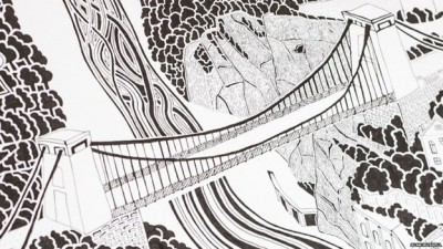
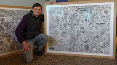
Artist Fuller’s intricate hand-drawn maps accepted by Bristol and London museums

BBC News 27 April 2016: http://www.bbc.co.uk/news/uk-england-36144041

http://www.fullermaps.com/


A Cartographic Turn

Maps & Mapping Posted on 18 Jan, 2017 13:02:40

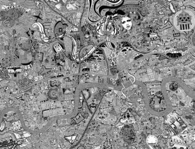
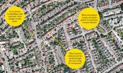
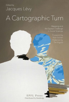
A Cartographic Turn: Mapping and the Spatial Challenge in Social Sciences
Jacques Lévy (ed.) EPFL Press (2016)

The Cartographic Turn contains contributions on maps and cartography from multiple authors from various disciplines: geography, demography, cartography, art theory, architecture and philosophy. While such diversity could imply that this book is a collection of independent contributions gathered only by their topic, this impression would be misleading. Rather, this book develops four simple propositions that actually can be streamlined into a single concept expressed through four different perspectives. Above all, maps convey rational, aesthetic, ethical and personal messages, at times separately but more often in unison, and this mix offers ample fields for studying social complexity. Beyond that, maps are, by their very existence, both representations of pre-existing spaces and creations of new spaces. Consequently, the historical or anthropological analysis of maps as semantic objects should be connected to the production of new maps, namely those that take advantage of the powerful tools provided by digital technology. Finally, the issues of contemporary mapping should be read in light of recent innovations within social sciences on space. Before this cartographic turn, technicians, historians, users and exegetes were distinct and decidedly turned away from each other.The era of the singular engineer-designed map is past. Maps have gained many new actors, and these actors are critical thinkers. This book would modestly like to contribute to a durable association between mapping and reflexivity. Cartographers, historians of cartography, geographers, visual scientists and artists, social scientists as well as advanced students in these disciplines will appreciate and benefit from reading The Cartographic Turn.

Contents

  • Foreword (Rob Kitchin)
  • Introduction: Mapping Is Thinkable, Thinking Is Mappable (Jacques Lévy)
  • Part 1: Map as Resource – When Maps Reflect (Christian Jacob) – Maps in Perspective, What can philosophy learn from experimental maps in contemporary art? (Patrice Maniglier) – The Cartographic Dimension of Contemporary Art (Marie-Ange Brayer) – What the Atlas Does to the Map (Elsa Chavinier, Carole Lanoix, Jacques Lévy and Véronique Mauron)
  • Part 2: Map as Language – Space for Reason (Jacques Lévy)
  • Cartographic Semiosis: Reality as Representation (Emanuela Casti) – Doing the Right Map? Cognitive and/or Ethical Choices (Jacques Lévy and Elsa Chavinier)
  • Part 3: Where Are We on the Map? – Mapping Ethics (Jacques Lévy) – A Reappraisal of the Ecological Fallacy – Mapping Otherness (Emanuela Casti) – Mapping the Global Mobile Space: The Nomadic Space as Sample (Denis Retaillé)
  • Part 4: Who is the Author of this Map? – ‘My’ Maps? On Maps and their Authors (Patrick Poncet) – Lost in Transduction: From Digital Footprints to Urbanity – Augmented Reality and the Place of Dreams (André Ourednik)
  • After Cartography (Tim Ingold)


Bike Share Mapping

Maps & Mapping Posted on 18 Jan, 2017 12:17:04

Bike share mapping creates beautiful portraits of London, NYC and Berlin

Researchers in Germany have turned GPS data from three major world bike share programmes into living, breathing visualisations of the cities themselves.

The Guardian, 9 August 2016: http://gu.com/p/4q2k4?


Early City Maps

Maps & Mapping Posted on 18 Jan, 2017 11:51:16

The Forbidden City to Convict’s Landing: rare early city maps – in pictures

From London when it had only one bridge, to a pictorial rendition of Sir Francis Drake’s invasion of Santo Domingo, these global city maps date back to the 1500s and are taken from Great City Maps, published by DK.


The Guardian
, 1 September 2016:
https://www.theguardian.com/cities/gallery/2016/sep/01/ancient-rare-early-city-maps-in-pictures?


New Book: Cartographies of Place: Navigating the Urban

Maps & Mapping Posted on 14 Aug, 2015 15:35:14

Cartographies of Place: Navigating the Urban
Edited by Michael Darroch and Janine Marchessault
(McGill-Queen’s University Press, 2015)

Media are incorporated into our physical environments more dramatically than ever before – literally opening up new spaces of interactivity and connection that transform the experience of being in the city. Public gatherings and movement, even the capabilities of democratic ideology, have been redefined. Urban Screens, mobile media, new digital mappings, and ambient and pervasive media have all created new ecologies in cities. How do we analyze these new spaces? Recognition of the mutual histories and research programs of urban and media studies is only the beginning. Cartographies of Place develops new vocabularies and methodologies for engaging with the distinctive situations and experiences created by media technologies which are reshaping, augmenting, and expanding urban spaces. The book builds upon the rich traditions and insights of a post-war generation of humanist scholars, media theorists, and urban planners. Authors engage with different historical and contemporary currents in urban studies which share a common concern for media forms, either as research tools or as the means for discerning the expressive nature of city spaces around the world. All of the media considered here are not simply “free floating,” but are deeply embedded in the geopolitical, economic, and material contexts in which they are used. Cartographies of Place is exemplary of a new direction in interdisciplinary media scholarship, opening up new ways of studying the complexities of cities and urban media in a global context.


Cartographica – Special issue – “Deconstructing the Map”: 25 Years On

Maps & Mapping Posted on 30 Mar, 2015 16:32:51

Cartographica

Volume 50, Number 1, Spring 2015

Special issue – “Deconstructing the Map”: 25 Years On

Articles to include:

Introduction: The Limits to Deconstructing the Map

Reuben Rose-Redwood

This
special issue marks the twenty-fifth anniversary of the publication of
J.B. Harley’s “Deconstructing the Map” (1989), which has had a major
influence in the fields of critical cartography, the history of
cartography, and human geography more generally. Over the last quarter
century, this essay and related works have also been widely cited by
scholars from a broad range of disciplines across the social sciences
and humanities, serving as a key reference for those seeking to theorize
the spatial politics of maps and mapping. Through such citational
practices, “Deconstructing the Map” has acquired a canonical status as
one of the classics of critical cartographic theory, yet the limitations
of its theoretical and methodological analyses are widely acknowledged
even by Harley’s strongest supporters. The contributors to this special
issue discuss their own critical engagements with this foundational text
as well as the extent to which Harley’s work still resonates with
contemporary perspectives in the field of critical cartography today.
The broader aim of this collection is therefore not to further canonize
Harley as the patron saint of critical cartography but rather to think
through the limits of “Deconstructing the Map” to ensure that current
and future theorizations of the power of mapping remain open to
self-critique and new becomings.

Cartography and Its Discontents

Matthew H. Edney

This Is Not about Old Maps

Denis Wood

“Snapshots of a Moving Target”: Harley/Foucault/Colonialism

Daniel Clayton

Reflections on J.B. Harley’s “Deconstructing the Map”

John Krygier

Harley and Friday Harbor: A Conversation with John Pickles

Jeremy Crampton and Matthew W. Wilson

Reflecting on J.B. Harley’s Influence and What He Missed in “Deconstructing the Map”

Martin Dodge and Chris Perkins

Tracing the Map in the Age of Web 2.0

Wen Lin

Still Deconstructing the Map: Microfinance Mapping and the Visual Politics of Intimate Abstraction

Sarah Elwood

Deconstructing the Map after 25 Years: Furthering Engagements with Social Theory

Leila M. Harris

Looking “beyond” Power: J.B. Harley’s Legacy and the Powers of Cartographic World-Making

Reuben Rose-Redwood

_______________________________________

Cartographica is available online at:

Project MUSE http://bit.ly/cartopm

Cartographica Online http://bit.ly/cartonline


New Book – Deep Maps and Spatial Narratives

Maps & Mapping Posted on 30 Mar, 2015 16:31:05

Deep
Maps and Spatial Narratives

Edited by David J. Bodenhamer, John Corrigan and Trevor M. Harris


Deep Maps and Spatial Narratives sets out to describe ‘deep mapping,’ an enhanced environment of data from widely distributed sources used to create a contextual view of a place, a network of social aspects, and environment, as the next step forward in the use of geo-referenced information. It spells out the state-of-the art in the use of new technology in mapping and geo-registration and its ramifications for history, geography, social sciences, cultural studies, environment research, and the humanities. The articles are filled with suggestions and viewpoints that are stimulating [and] the questions raised numerous and complex.”—Lewis Lancaster, University of California Berkeley

Deep maps are finely detailed, multimedia depictions of a place and the people, buildings, objects, flora, and fauna that exist within it and which are inseparable from the activities of everyday life. These depictions may encompass the beliefs, desires, hopes, and fears of residents and help show what ties one place to another. A deep map is a way to engage evidence within its spatio-temporal context and to provide a platform for a spatially-embedded argument. The essays in this book investigate deep mapping and the spatial narratives that stem from it. The authors come from a variety of disciplines: history, religious studies, geography and geographic information science, and computer science. Each applies the concepts of space, time, and place to problems central to an understanding of society and culture, employing deep maps to reveal the confluence of actions and evidence and to trace paths of intellectual exploration by making use of a new creative space that is visual, structurally open, multi-media, and multi-layered.

David Bodenhamer is Executive Director of The Polis Center at IUPUI and Professor of History. He is co-editor (with John Corrigan and Trevor M. Harris) of The Spatial Humanities: GIS and the Future of Humanities Scholarship (IUP, 2010).

John Corrigan is the Lucius Moody Bristol Distinguished Professor of Religion and Professor of History at Florida State University. He has authored or edited numerous books on the history of religion, including
Religion and Space in the Atlantic World (forthcoming).

Trevor M. Harris is Eberly Professor of Geography at West Virginia University. He is one of the early contributors to the GIS and Society critique of spatial technologies.

Indiana University Press

February 2015 256pp 36 b&w illus., 5 maps, 2 tables 9780253015600
£21.99 now only £16.49 when you quote CSL215DEEP when you order.

http://www.combinedacademic.co.uk/deep-maps-and-spatial-narratives


New Book – Cultural Mapping and the Digital Sphere

Maps & Mapping Posted on 30 Mar, 2015 16:27:31

Cultural Mapping and the Digital Sphere: Place and Space

Ruth Panofsky & Kathleen Kellett, Editors

University of Alberta Press (May 2015) ISBN: 9781772120493

“Notwithstanding their differing approaches—digital, archival, historical, iterative, critical, creative, reflective—the essays gathered here articulate new ways of seeing, investigating, and apprehending literature and culture.” – From the Preface

This collection of fourteen essays enriches digital humanities research by examining various Canadian cultural works and the advances in technologies that facilitate these interdisciplinary collaborations. Fourteen essays in English or French survey the helix of place and space: While contributors to Part 1 chart new archival and storytelling methodologies, those in Part 2 venture forth to explore specific cultural and literary texts. Cultural Mapping and the Digital Sphere will serve as an indispensable road map for researchers and those interested in the digital humanities, women’s writing, and Canadian culture and literature.

http://www.wsupress.wayne.edu/books/detail/cultural-mapping-and-digital-sphere


Literary map of Edinburgh launched

Maps & Mapping Posted on 30 Mar, 2015 16:10:49

Edinburgh’s literary history mapped at the click of a button ‘Lit Long’, a searchable interactive map of the city, will take users to locations made famous by Scottish writers from Walter Scott to Irvine Welsh – and tell you what they wrote
The Guardian
, 28 March 2015

http://www.theguardian.com/uk-news/2015/mar/28/edinburgh-literary-history-online-map-lit-long?CMP=share_btn_link


How Google and Apple’s digital mapping is mapping us

Maps & Mapping Posted on 09 Jul, 2014 09:53:46

This is quite an old Guardian article now (August 2012), but as I just found a print copy whilst sorting out some old papers I thought it worth posting to keep a record of it.

How Google and Apple’s digital mapping is mapping us

Digital maps on smartphones are brilliantly useful tools, but what sort of information do they gather about us – and how do they shape the way we look at the world?:

http://www.theguardian.com/technology/2012/aug/28/google-apple-digital-mapping


Kerouac’s On the Road followed on the road via Google Maps

Maps & Mapping Posted on 06 May, 2014 18:52:36


Guardian article
about free eBook, On the Road for
17527 Miles
by
Gregor Weichbrodt, which maps the route of Jack Kerouac’s On The Road, with
Google driving instructions.

Read article here

Access eBook here


Off the Map by Alastair Bonnett – review

Maps & Mapping Posted on 06 May, 2014 18:33:50


New book by Alastair Bonnett: Off the Map: Lost Spaces, Invisible Cities, Forgotten Islands, Feral Places and What They Tell Us About the World (Aurum Press Ltd, 2014)

Review of book in The Guardian – read here

Review in The Telegraph – read here


Israeli group puts 1948 Palestine back on the map

Maps & Mapping Posted on 06 May, 2014 17:42:18

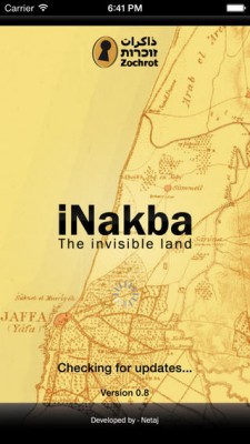
Remembering the Nakba: Israeli group puts 1948 Palestine back on the map

Guardian article about an app designed by the Israeli activist organisation Zochrot. The i-Nakba phone app will allow users to locate any Arab village that was abandoned during the 1948 war on an interactive map, learn about its history (including, in many cases, the Jewish presence that replaced it), and add photos, comments and data.

Read more at: http://www.theguardian.com/world/2014/may/02/nakba-israel-palestine-zochrot-history


Why Google Maps gets Africa wrong

Maps & Mapping Posted on 08 Apr, 2014 17:29:45


Useful article in The Guardian on the history and politics of map projections in relation to the African continent (article originally published in Think Africa Press):

http://www.theguardian.com/world/2014/apr/02/google-maps-gets-africa-wrong


Next »